


Satellite captures 3,000-km-long band of cloud from Kerala to Arunachal Pradesh
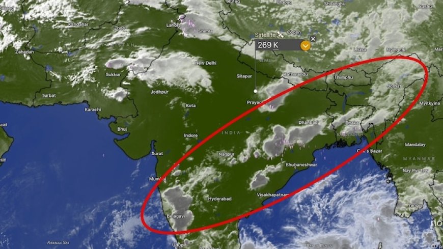
A MASSIVE band of thunderstorms stretching nearly 3,000 km from Kerala to Arunachal Pradesh has been captured in satellite imagery, highlighting the scale of atmospheric instability currently building across India ahead of the southwest monsoon.
The unusually long chain of cloud systems extends from the southern tip of the peninsula across central and eastern India before reaching Assam and Arunachal Pradesh in the northeast.
Weather experts say the formation represents a continuous “channel of thunderstorms” capable of producing widespread rainfall, lightning activity and dense cloud cover across much of the country.
Meteorologists analysing the imagery described the system as a remarkably organised corridor of convective activity spanning nearly the entire length of the Indian subcontinent.
“This is a surprisingly long chain of thunderstorms forming from Kerala and reaching all the way to Assam and Arunachal Pradesh,” weather analysts said. “If someone were travelling through this corridor, they would likely encounter clouds and rain for most of the 2,000 to 3,000 km journey.”
The cloud band appears to be driven by a combination of strong surface heating, moisture incursion from the Arabian Sea and Bay of Bengal, and atmospheric disturbances interacting over the Indian mainland.
Such conditions are common during the transition period before the monsoon onset, when intense convection begins building over land and sea.
Satellite observations indicate that multiple thunderstorm clusters embedded within the band are growing vertically, suggesting strong updrafts and unstable atmospheric conditions. These systems can trigger heavy rain spells, gusty winds, lightning strikes and short-duration localised flooding.
The formation also points to the growing complexity of India’s pre-monsoon weather patterns, where isolated storms are increasingly linking into larger mesoscale convective systems covering vast geographic regions.
Several states along the corridor, including Kerala, Karnataka, Maharashtra, Telangana, Odisha, West Bengal, Bihar, Assam and Arunachal Pradesh, are likely to experience intermittent thunderstorms and rainfall activity as the system evolves.
Weather officials continue to monitor the cloud mass using high-resolution satellite imagery and Doppler radar observations to assess storm intensity and movement.
The development comes at a time when large parts of north and central India are already witnessing volatile weather conditions, including heatwaves punctuated by sudden thunderstorms and dust storms.
Experts say such large interconnected storm bands could become more frequent as rising temperatures pump additional moisture and energy into the atmosphere.